When you started your masters in 2019, did you consider that your thesis might lead to a publication?
'Not for a moment. I barely had any experience of publishing. During my bachelor in China, I got sporadic exposure to it, but nothing more. Associate professor Tiejun Wang (ITC faculty, department of Natural Resources NRS, ed.) introduced the topic to me in 2020 after the pandemic and I immediately found it interesting and became very enthusiastic. Counting animals from space, sounds really cool, right? Moreover, I realised that the subject could be of significant value.'
Your research is about counting and locating wildebeest and zebra with artificial intelligence. How did you come to that topic?
'There are two reasons for this. First, Tiejun Wang had been working with PhDs on animal detection for some time, but it was still through more traditional ways. He was keen to try a different way, using newer techniques. In addition, the subject attracted me enormously because the research combines different techniques, such as remote sensing and deep learning. Combining that with interesting themes such as biodiversity and wildlife appealed to me enormously.'

You are a Chinese student, doing a master's degree in the Netherlands and then think of counting wildebeest and zebra in the Serengeti. From where did the research attract you?
'Those locations do not affect my choices. In contrast, the fact that the research means more than just counting animals does. Mapping wildebeest populations also says something about biodiversity and vegetation. The Serengeti-Mara ecosystem is very dynamic. How wildebeest live has an impact on the whole area, both ecologically and financially.'
Can you explain that?
'In my research, we map populations via satellite. Those counts proved to be very precise and have many advantages over previously used ways such as cars, planes and drones. Those counts were not only less accurate, but also much more intensive and difficult to carry out. The area we are talking about is huge. By knowing where populations live, and how, authorities can make better policy. Ecologically, but also financially. Think about tourism, for example.'
The publication has 14 author names. How did this collaboration come about?
'During the research, Tiejun Wang and I noticed that we might be onto something big. Then we explored collaborations with experts from Kenya, but also with universities in the US and the UK. The last part of my masters consisted almost exclusively of giving presentations. Those collaborations only made the research bigger, resulting in this publication.'
You completed your master's at the end of 2021. What do you hope your work will bring for the future?
'I am now working temporarily at the University of Copenhagen and hope to pursue a PhD in Hong Kong. I hope my thesis will trigger even more research. I have mapped sections of the Serengeti using currently available data, but they remain fragmented. I hope the work will lead to mapping precise numbers of the whole wildlife populations. That even more data can be collected and that the data can also be analysed. Also, when we talk about climate change, it will be interesting to see if the behaviour of populations of wildebeest changes. That they leave a place earlier, or take different routes. There are countless interesting ways to do further research.’

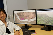
Approximately 120.000 individual wildebeests are accurately detected by the algorithm in this large area. Each purple dot is one wildebeest.