ITC scientists Norman Kerle (Professor of Geoinformatics for Disaster Risk Management) and Francesco Nex (Associate Professor in the Earth Observation Science Department) have both worked on various projects related to post-disaster help, including the use of satellite data, UAV imagery and indoor drones.
They have collaborated directly with first responders to identify the main challenges and create solutions that can truly help in rescue missions and damage assessment. They developed solutions that could potentially save lives, but – as they say themselves – very few of them are being used. ‘It’s a shame,’ says Kerle. ‘We do very relevant science here, but as a community we need to adjust to a more impact-oriented approach.’
Satellite data
The researchers have worked on algorithms to analyze satellite or drone data to assess the damage and help decide where to prioritize search and rescue. Interpreting satellite data and identifying the damage is very important, especially in case of a large disaster when multiple cities over a vast area are affected, and potentially thousands of buildings have collapsed, as was the case in the recent Turkey-Syria earthquake.
‘You need to know where to go first, and also determine where survivors are most likely to be found,’ says Kerle. ‘I must say that I’m a little disappointed in how geodata-based support is used. There are special organizations that are dedicated to interpreting the satellite data and providing damage accurate maps. However, even more than 48 hours after the event no detailed maps were available. The reason for this is that any cloud cover effectively delays the availability of suitable satellite imagery, and in addition the maps are created manually, which takes a lot of time.’
Automation
‘We have worked on automated image interpretation using deep learning for many years now,’ adds Nex. The ITC scientists are developing algorithms that are able to extract information automatically and provide accurate information for rescue missions very quickly.
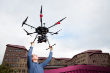
‘We are using satellite data, as well as high resolution images made by drones in real time. We have worked with customized drones, as well as commercial drones that can be readily bought and directly used. We have developed artificial intelligence (AI) that detects victims in images by identifying not only bodies, but also smaller body parts – because people are often hidden under the debris and not fully visible. The AI can therefore find a victim even if only a hand is visible,’ explains the Associate Professor.
The researchers have also developed a system for indoor mapping. ‘There are usually several earthquakes right after each other, which poses a danger for rescuers,’ says Nex. ‘They might walk into a building and it can collapse on them, while they are trying to rescue someone. For this purpose, we are using custom-made drones that go inside buildings and, in addition to identifying visible victims, deliver semantic information, so that the first responders have a better idea of the situation before they enter the building.’
From prototype to the market
All these solutions are functional, but the community has been struggling to bridge the gap between a research prototype and a market-ready product. ‘Because of how established organizations work and how funding is organized, the solutions face multiple challenges to make it to practice,’ says Kerle. ‘For example, funding schemes such as Horizon Europe focus on developing and testing. In short: the funding allows for great science, but doesn’t lead to finished products. Organizations also have protocols on how they work, what type of equipment they use and prefer to use simple tools that they already have. Some of our technology is still too fragile and too complex for them.’
‘At the same time, our solutions are close to being usable in operational scenarios,’ stresses Nex. ‘They can work in real life, but it’s a matter of opportunity. We need the opportunity to bring them to the market. We have working prototypes, but closing the gap between a prototype and a finished product that people can buy is a challenge. Even though these solutions could potentially save lives and make people’s work much better and easier. We could do more. I’d love to be able to say that our tools can help after the next disaster.’