The event was co-organized by the ITC faculty of the University of Twente and Red Cross and it also included volunteers in Delft and Nairobi. The Mapping Party, which was a part of the Missing Maps project related to the Princess Magriet Fund of the Red Cross, was attended by Her Royal Highness Princess Margriet herself and the project’s ambassador André Kuipers, an ESA astronaut.
‘Maps are archives of information’
‘If a disaster happens, it is important to know how the affected area looked before and where to send help. It is therefore important to have high resolution satellite images available, so we can see what is gone,’ explained André Kuipers. ‘However, satellites only provide images, while maps are archives full of information.’
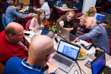
With this in mind, ITC has started a project ‘Mapping vulnerable communities in Malawi’, because when a disaster strikes or is anticipated, proper maps are necessary in order to organize effective help for vulnerable people. Yesterday’s Mapping Party was a part of this initiative and supposedly the biggest mapping event ever organized in the Netherlands.
Putting 100 million people on the map
‘We are here as a part of the Missing Maps project by the Red Cross, which has the goal to map vulnerable areas and help humanitarian organizations in providing help,’ said Maarten van der Veen from the Red Cross. ‘The Missing Maps project works in three stages: making maps by volunteers all over the world, using locals to fill in details into the maps and then using the maps to plan risk reduction and disaster response activities. Our goal is to put 100 million most vulnerable people on the map within the next two years. Just today, we should put about 250.000 people in Malawi on the map.’
Why is mapping important for Malawi? ‘Malawi is a poor country, which suffers from seasonal flooding. Although people prepare for these floods, sometimes they are too big, such as the one last year,’ clarified Van der Veen. ‘There are many empty spots on the map of Malawi, but thousands of people live in those unmapped areas. However, not being on the map, it is difficult to include them in policies and help.’
Connecting remote volunteers and locals
To improve this situation, volunteers at the Mapping Party were creating a map of Malawi based on satellite images. Each participant was assigned a small area and was tasked with marking buildings or roads in the map. Later on, locals in Malawi will fill in details into the map, such as names of hospitals, information on water points and so on.
‘Connecting these two groups – remote volunteers and locals – is a goal of this project. It is a powerful combination,’ pointed out Maarten van der Veen. ‘The map will be created on OpenStreetMap, which is a platform similar to Wikipedia – anyone can contribute and the information is instantly available to everyone around the world.’