The key note speech of Maria Coetzee from South Africa showed a snapshot of the issues being addressed at this ITC Conference. ‘Cities and especially metropolitan regions, have featured prominently in South Africa’s troubled political past and are increasingly “home” to the many millions who have chosen, and are still planning to call it such in years to come’, Coetzee said. ‘South Africa’s recently adopted National Development Plan outlines a trajectory in which the 59.3% of South Africans who lived in urban areas in 2005 will swell to 71% in 2030.’
These are major issues, especially since, according to Coetzee’s data, have 40% of the population living on only about 3% of the land in South Africa. These people in cities and metro areas generate 65% of the economy, so whenever urban planning is overlooked or mismanaged or underfunded, it matters, and it has larger ripple effects throughout the entire country.
The high population and dense urban areas also create an environment for one of the worst income inequalities in the world, that, combined with an enormous amount of immigration to South Africa and ‘spacial challenges, it is further marginalizing the poor’, Maria stated.
Accurate and accessible GIS mapping
These issues along with ‘modeling flooding in Kampala, Uganda’, to ‘The diffusion of networked social movements and emergence of hybridization of public spaces’ to ‘Water urbanism in Bogota‘ all point to a central theme. That theme is the importance and absolute necessity of accurate and accessible GIS mapping and the social dimensions and complexities of the Urban Development World.
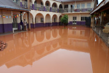
One of the lectures on Thursday was called ‘Will urban agriculture survive the growth of African cities? A case study in Kampala.’ In the talk, Karolien Vermeiren spoke of the huge obstacles being faced by the over 1.8 million citizens in the Kampala region. ‘The city has an annual growth of around 5.3%, and that coupled with weak urban planning, and socio-economic and physical problems that are getting worse each year such as traffic, slums and regular flooding’ combine she said, to make for a pretty uncomfortable and seemingly tumultuous situation for the people of Kampala. When you add it up, it makes for a unique set of solutions, one’s that Vermeiren found fascinating.
Her GIS systems and mapping found that Urban farming is crucial for many of those depending on subsistence farming, and those who are common gardeners. These avenues of Urban Gardening and Peri-Urban methods use space that is flood-prone and usually reserved for waste-water. ‘It was pretty amazing to see the topographic state of the farming of wetlands, and it also alarmed me to see them using waste water. That is hazardous’ Karolien said. ‘Over all, I was happy about the acceptance of our research there in Kampala and the acceptance of the people we were questioning about this land use. They seemed relieved that someone was paying attention to it after all this time.’