Funding for two UT projects
Two UT projects were awarded funding from the NWO Open Competition Domain Science-M programme last week. M-grants are intended for innovative, high-quality, fundamental research and/or studies involving matters of scientific urgency. Next to SPACE4ALL, UT Assistant professor Hanyuan Hang (Mathematics of Operations Research research group) will be conducting research on ‘Statistical analysis of boosting algorithms for classification’.
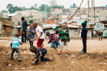
‘The goal of SPACE4ALL is to combine earth observation data and citizen science data to train artificial intelligence models that help us map climate vulnerability of people living in slums,’ summarizes ITC researcher Mariana Belgiu, who runs the project together with her ITC colleague Monika Kuffer and with Anne Dijkstra, assistant professor in Science Communication (BMS faculty). ‘We are very happy with the M-grant, because this funding allows us to collaborate even though we are from different faculties.’
Accurate data
The UT scientists initiated the project because they wanted to raise global awareness, explains Kuffer. ‘We’d like to promote investments in poor urban areas, but one of the main bottlenecks we face is the lack of data. There is no data on how vulnerable people in slums actually are. We know that they live in more flood prone areas, with risk of landslides, and that they are usually in difficult social and economic situation. However, there is little scientific evidence on how much more they are impacted than other urban areas. We need to fully understand the local situations in order to help.’
The project will cover informal settlements in large and secondary cities in Kenya, Nigeria and Ghana. ‘We will be collecting information on socioeconomic situation in slums, on local infrastructure, health and public safety. We will combine this with satellite data and use it all as input for deep learning models,’ says Belgiu. ‘Our deep learning algorithms are very powerful but they need the accurate data from citizen science to run the models.’
Citizen science
That is why citizen science is such an important part of the research, explains Dijkstra. ‘We will collect data directly with citizens, but we will also give back to the people. Our plan is to co-develop an app that the locals can use. The general idea is to provide them with information on risky spots, upcoming weather events that could cause flooding and so on. We aim to understand how to give the data back to the citizens, so that it is useful for them. We will be working directly with local communities to understand their perspective.’
The project cannot succeed without involvement of the locals, agree the scientists. ‘Slums are extremely complex environments that are hard to map. If you currently run a flood model on an informal settlement, you get inaccurate information, because you are missing the detailed information on the area. For example, drains are often blocked in slums, which changes the situation,’ explains Kuffer. ‘We have good technology, but it is not really used to map poor areas and to benefit the most vulnerable. We need to reduce this gap.’