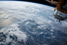
ITC scientist Peng Jia specializes in combining spatial science and public health. ‘Spatial technologies can help us address traditional limitations of public health research,’ he says. ‘For instance, epidemiology often uses questionnaires and human labor. Even the use of Geographic Information Systems has been popular, but the information on the environment derived from there remains quite limited.’ Which is why Jia suggests to use remote sensing. ‘Satellites are always orbiting Earth, sending frequent photos – images that we can use to monitor the environment.’
Monitoring diseases
Having detailed information about the environment can help us to quickly detect any changes which could signal outbreaks of diseases. Moreover, it can contribute to tackling chronic diseases and one of the main risk factors related to chronic diseases: obesity, which is the focus of Jia’s paper ‘Spatial technologies in obesity research: current applications and future promise’ published in the latest ‘Trends in endocrinology and metabolism’.
How exactly can we see obesity from space? ‘There are certain environmental factors that are related to obesity risk,’ explains Peng Jia. ‘These are, for example, residential density and greenness of the neighborhood. In the U.S., if there is a lot of residents in a suburban area, the neighborhood is usually considered safer and people are more inclined to go outside and move. However, this also depends on the socioeconomic status of the neighborhood. If the area is considered poor and dangerous, high residential density leads to a higher obesity risk. The street connectivity is also important. Is it easy to walk around? All that relates to obesity and can be monitored using satellite data.’
Building healthy environments
How about other environmental aspects, such as restaurants or sport facilities in the area? ‘Those are also very important for identifying obesogenic zones. Indeed, if there are only fast food restaurants and no shops with fresh food in the neighborhood, the obesity risk could increase. But we can’t see supermarkets and restaurants from space. We can, however, get this information by using other types of spatial and location-based technologies on the ground, such as Global Positioning System and smartphone-based apps, and combine it with satellite data.’
Jia’s work shows that, even though remote sensing is only one part of the model, it can play a vital role in obesity prevention. ‘The main goal of our paper was to introduce these pioneering spatial methods in public health areas. It was targeted at public health researchers to get them acquainted with the methods,’ says Jia. ‘Furthermore, our findings could be used by urban planners and policy makers so they can build “healthy” environments.’